
Road Asset Management System (RAMS): AI & GIS for Infrastructure Management in Pakistan
Services Covered:

Government & Public Safety

11 months

200K - 999K

1 November 2024

16-20

Onshore
Project Capability Score (PCS)

Project Capability Score (PCS) is not available for this project because it has not been endorsed yet. Once an endorsement is added, the score can be calculated based on project feedback, company track record, experience, and recency. Learn more about PCS
Client
Adam Smith International
 Peshawar, Pakistan
Project Summary
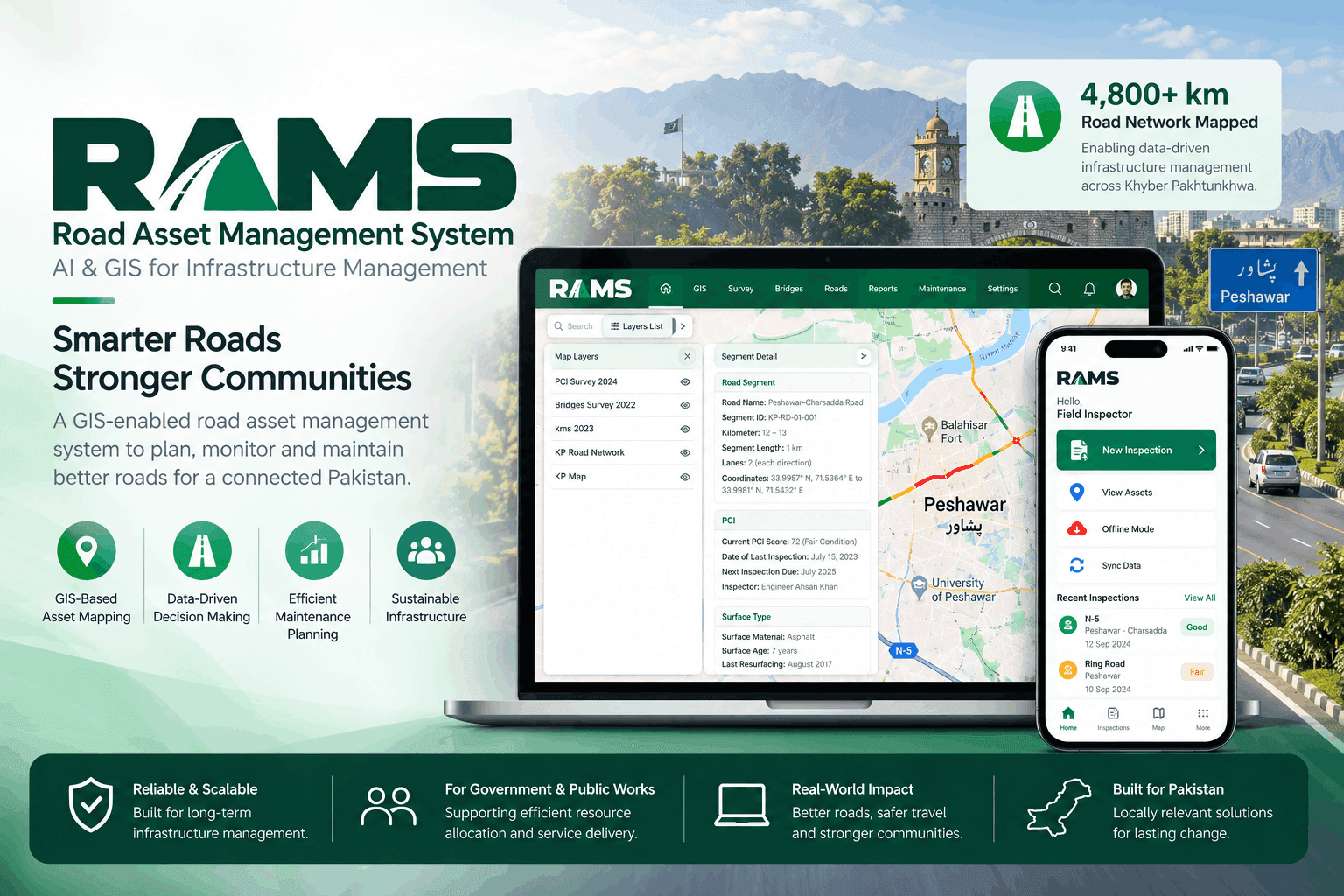
RAMS (Road Asset Management System) is an AI and GIS-enabled road asset intelligence platform developed by Centangle for public-sector infrastructure management. The platform digitizes road networks, centralizes asset and inspection data, uses computer vision to detect visible defects such as cracks and potholes, and provides GIS-based dashboards for monitoring road conditions and planning maintenance. RAMS brings road data, spatial mapping, AI-supported assessment, reporting, and maintenance workflows into one structured environment, helping infrastructure teams move from fragmented records and manual inspections toward more proactive, evidence-based decision-making.
Key Challenges
Road condition information was fragmented across field reports, spreadsheets, legacy records, and manual inspection formats, making it difficult to maintain a reliable view of infrastructure health. Heavy dependence on field surveys increased the time and effort required for monitoring, while inconsistent assessment formats made comparison and prioritization difficult. Decision-makers also lacked centralized spatial visibility into road conditions, defect locations, and maintenance priorities, resulting in a largely reactive approach to infrastructure maintenance.
Project Deliverables
- AI-powered road defect detection using computer vision
- GIS-based road network and asset mapping
- Centralized road asset registry
- Digital inspection and condition assessment workflows
- Road condition and defect dashboards
- Role-based dashboards and access controls
- Maintenance prioritization and planning workflows
- Reporting and infrastructure intelligence dashboards
- Structured inspection and asset data management
- Platform deployment and continuous improvement framework
Project Solution
Centangle developed RAMS as a governed AI and GIS-enabled road intelligence platform. The solution combines computer vision for AI-supported defect detection, GIS mapping for spatial analysis, a centralized road asset registry, inspection and condition records, role-based dashboards, reporting, and maintenance prioritization workflows. The platform provides a unified view of road networks, asset conditions, defects, inspection history, and maintenance requirements, enabling infrastructure teams to assess conditions more consistently and make evidence-based decisions across large road networks.
Project Outcome
RAMS digitized and enabled monitoring of more than 25,000 km of road infrastructure while reducing field survey effort by more than 60%. The platform provides infrastructure teams with a centralized view of road conditions, asset locations, defects, and maintenance priorities. By combining AI-supported defect detection with GIS-based visibility and structured workflows, RAMS helps shift road asset management from fragmented inspections and reactive reporting toward more proactive, data-backed infrastructure planning.
Platforms
 AI/ML Platform
 Cloud
Cloud API/Integration Platform
 CMS
CMS Desktop
 Mobile
 Web
Web
Tech Stack
.svg&w=48&q=75) Amazon Web Services (AWS)
Amazon Web Services (AWS) Android
 Angular
 Apache Tomcat
 ASP.NET Core
 ASP.NET Web API
 Azure DataBricks
 C++
C++ Preact
 Python
 Redux
Redux REST API
 Tailwind CSS
 Vite-React
 QGIS
QGIS VisionLidar
More Projects by Centangle Interactive

WordPress Website Design & Development for Renewable Energy Company
Services Covered:
Agency name:

Centangle Interactive
Project capability score (PCS):


Rehnuma Awaz: AI-Powered Urdu Screen Reader for Blind Users in Pakistan
Services Covered:
Agency name:
Centangle Interactive
Project capability score (PCS):